The Hiking Thread

We hiked the Ventura Botanical Gardens today - it was free on New Year's, so we took advantage of that to drive down. Ventura is about 90 minutes south of us.

It was a very windy day and not a good day for photography, so the pictures below are from the Internet.

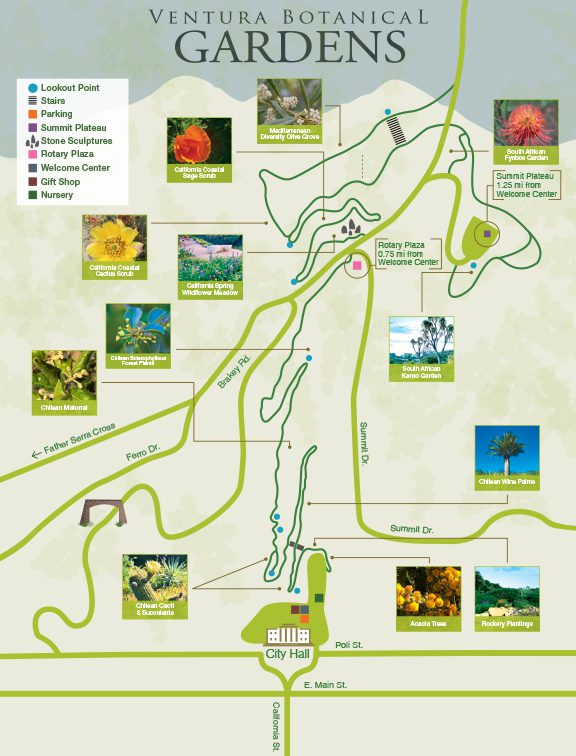
It's 1.25 miles of switchbacks from the parking lot to the highest parts of the garden, and maybe 500 to 750 feet of elevation gain. The park contains a lot of flora from many areas of the world: in addition to native California species, there are also areas devoted to plants from Chile, Cape Town, South Australia, and the Mediterranean Basin. The plants from South Africa were the most spectacular at this time of year.

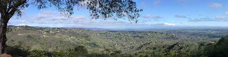
Once you get up a little ways and are facing west, you can see the Channel Islands (on a clear day). We could barely make them out today.

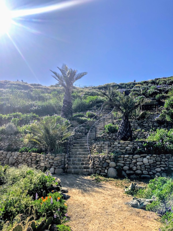
A good way to describe the park is that it's a sculpture garden without the sculpture. Lots of stonework: walls, benches, and rocks, with engravings from poets and naturalists and songwriters. My favorite had this quote from John Muir: "Of all the paths you take in life, make sure a few of them are dirt."

Our plan is to do at least one hike every month in 2023 - it's not really a New Year's Resolution, it's more an aspiration. And a hike doesn't have to be so grueling that it has a person begging for mercy from the Goddess of Agonizing Blisters - it can be something like what we did today.

VBG20_Map_Digital.jpg


1672621367571.jpeg

ventura+botanical+garden+4.jpg
 
Last edited:
I took today (Friday April 14) as a vacation day so that Mrs. TR and I could check out the Super Bloom.

We went to Carrizo Plain National Monument, which is about 2 hours from where we live in Central Coast California. The weather was clear and sunny and temperatures were in the low 60s, perfect for hiking.

We decided to enter the monument at the North Entrance, so that meant going north on the 101 through Pismo Beach, where we stopped for buns and coffee at Old West Cinnamon Rolls, which is well-known locally.

We were hoping that this year's Super Bloom would be on par with the 2017 event, which is shown below in an image from the Internet:

33527510610_35306d22ca_b.jpg


We didn't quite see that, but it was still amazing. The rest of the photos in this post are from my cell phone.

Shortly after entering the park, there's a scenic outlook. We climbed to the top of that (5 minutes) and got a nice view of Soda Lake.

1681519742766.png1681519686661.png

We then drove down to the Visitor's Center and got a map and spoke with one of the rangers. We decided to forgo climbing the 5000' peak that was near us, and instead chose to go to Wallace Creek, which offers 20 and 45 minute hikes. We opted for the 45 minute hike, but it turned into a slightly longer hike due to many stops just to enjoy the scenery.

1681520012106.png

Here's a view when we we're just starting out:

1681520088229.png

And here's a shot (that didn't come out very well at all) that shows the San Andrea Fault. It's really very striking up close, when you're standing on the Pacific Plate and realize you could walk another half hour and be standing on the North American Plate.

1681520283261.png

After we finished up the Wallace Creek hike, we drove for about an hour south through the monument until we came to the KCL Campground, where we had the lunch I had prepared earlier that morning: BLTs on country white bread, oranges, Reese's Cups, and water.

If there's a better sandwich to have when hiking than a BLT, I haven't found it.

We came home via Route 166 west, and that turned out to give me my best shot of the day when we were about halfway home. The Super Bloom isn't confined to the Carrizo Plain National Monument, it's occurring in many places in California and Arizona.

1681520598873.png

When we got home, we had raviolis and Ragu, with some fresh lettuce and an acceptable Pinot Noir. Dessert was pound cake with whipped cream and strawberries.

Here's a display that we saw at the Visitor's Center:

1681520869451.png

Those weren't the only flowers we saw, there were also wild lupines everywhere - vivid blue-purple flowers in clumps that would cover a baseball diamond.

Up until a few weeks ago, I had never heard of the Carrizo Plain National Monument, even though it's only two hours from where I live. It's an amazing place.
 
Last edited:
I started this thread with a post about about Mt. Whitney, which is in Inyo County. Mrs. TR and I had a great experience that day.

Unfortunately, things can go south very quickly when hiking. Here's a sad story about a hike that went badly for some hikers in that area.


1688825800540.png
 
Started off the MLK weekend by taking today (Friday) off, making it a four-day weekend.

We needed to be in Atascadero to pick up some plants we had ordered at a nursery there, so we looked for a hike in the area, and found one called Three Bridges Oak Preserve. Atascadero is about an hour north of where we live.

Here's the trail map : the trailhead is at the bottom of the map.

1705102800639.png

Here's a nice view from one of the lookouts on the trail:

1705103608345.png

The trail is very well marked and features lots of signage about the native foliage.

threebridges1.jpg threebridges2.jpg

We hiked for about 90 minutes, from ~1100 to 1230 or so. We are no longer at the age and stage where we go from dawn to dusk and do thousands of vertical feet. We did about 400 vertical feet I think, and the total length of the hike was about 3 miles. Weather was terrific, sunny and in the high 50s.

After we finished the hike, we went to the nursery to pick up the plants (1 peach tree, 1 fig tree, 6 raspberries and 5 roses)

We then ordered the lunch specials at a local Thai place (1 red curry, 1 pineapple fried rice).
 

Attachments

  • 1705103515606.png
    1705103515606.png
    95.6 KB · Views: 1
We hiked Point Sal today - the full hike is a 10 mile out-and-back. We did half of that: 2.5 miles out to a nice look-out point, and then back again. We did it in the morning, as we're due to get a bit of an atmospheric river event starting this afternoon.

Here are some photos, starting with the view from near the trailhead as we're just starting out. That hill is just a local maximum - there was still a fair amount of climbing to do after we crested that point.

1708205502449.png


Here's a shot from half-way up that hill, looking back at the trailhead parking lot:

1708205928570.png


Here's a view looking north. What you can see on the upper left are some of the agricultural fields in the Betteravia area - rich farmland between Santa Maria and Guadalupe.

1708206332997.png


Here's a view west from the turnaround point. It was very windy, so I think the cell phone camera wasn't held as steadily as it should have been.

1708206611993.png


On the way back, we got a good view of Vandenberg Space Force Base. The tall white structure in the top-center-right is Space Launch Complex 3. Just to the right of that is SLC 4, but there wasn't a rocket on it this morning so it's not visible in this photo. Near the center of the picture are Wall Beach and Surf Beach, also located on VSFB.

1708206876619.png


Here's a nice shot of a hillside that dominates the view during the last mile of the hike.

1708207163251.png


All in all, a very nice hike - it took us about two hours to do the 5 miles. Along the way we saw a lot of wild sage and California buckwheat, also some fennel and California artemisia.

And the pictures don't really do justice to the scenery, but I think a better photographer would get a lot closer to capturing the essence of that part of the Central Coast. :biggrin:
 
Last edited:
We hiked the Reservoir Canyon Loop Trail today. It's located just north of San Luis Obispo, about 40 minutes from where we live.

Here's the topo map of the trail.

1712444851461.png

The trail head is at the top of that map, and so the trail begins and ends with the falls. Here's a short video I took of the falls:

View attachment 20240406_125211.mp4

Here's a nice shot of the hills to the north. The camera doesn't do justice to the reality - the greens are much more intense than what is shown here, and the hills looks as smooth and velvety as the top of a pool table.

1712445293462.png

It took us about 3 and a half hours to do the 5.5 miles. We're senior citizens now (70 for me, 66 for my trophy wife), and so we tend to be a little more careful during the steep descents. But that's OK, it means we're outdoors longer, doing one of our favorite activities. We're surfing the Earth instead of surfing the Net.
 
Back
Top